The Resort Years
First Investment Company
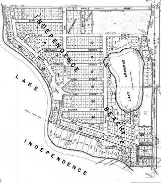
In 1925 the Pieper property, minus the resort buildings bought by the Wilsons, was sold to First Investment Company. The resort property and buildings became Wilson's Independence Beach Resort. That same year, First Investment Company subdivided the remainder of the property into small lots lining residential streets.
It’s been speculated that when the owners of First Investment Company drew the plat map, they were meeting somewhere in Minneapolis, were not that familiar with the property, and were probably intoxicated, because they laid out the streets with no regard for topography or wetlands.
Most of Independence Beach was divided into 60 ft wide x 100 ft deep lots. The original plat shows Fern, Walnut, Pine and Balsam Streets but it also shows several streets that were never developed -- Beechnut, Spruce and Ash were platted between Pine and Walnut. Most of this low-lying area is now owned by the City of Medina and is designated as the Ardmore Nature Area. The right-of-ways for the undeveloped streets are still shown on the map that can be found on Hennepin County’s website under Property Information (searchable by address). Walnut was platted as extending all the way to County Road 19. Cedar Avenue was shown extending south to Ash Street just east of the park. What is now Ardmore Avenue was called Maple Avenue. A street called Palm Street branched off from Maple south of Lake Ardmore. On the plat, Lakeshore Avenue turned at what is now Brook Street, and continued out to County Road 19. However, the streets were not utilized exactly as shown on the plat. From the aerial photos taken in 1937 and 1945, it appears that the most traveled route from Lakeshore turned left on Pine then right on what is now Ardmore out to County Road 19. The extension of Lakeshore was not completed until after 1950.
Sometime later (map at left), Lakeshore was extended to its current location and a portion (where Brook Street is now) was re-named Main Street.
Lakeshore Park was designated as a park in the original plat. A narrow strip of land along the lakeshore was shown as "Dedicated to Public for Beach". A plat map from 1956 still shows this beach, but today the lake is higher and most of the beach has disappeared under water, except for a small area on either side of the boat launch. The small pieces of property along the lakeshore shown on today's property maps may also have been part of the original "Beach" area. When First Investment went bankrupt, the strip of land was considered an asset and was sold to Frank Hopkins.
The part of the development where Fern, Walnut, Pine and the undeveloped streets were platted was not wooded at that time; it was mostly hay fields. The developers planted hundreds of ash trees along most of the platted streets. Aerial photos on Hennepin County's website dated 1937 and 1945 clearly show the rows of trees lining the streets. Some of these trees may still exist but the rows have become obscured.
In 1925 and 1926, First Investment heavily promoted the development with large newspaper ads. Apparently the Independence Beach portion of First Investment's business was legitimate, but the other properties First Investment was developing, as well as many other business owned by the parent company, were involved in a huge financial scandal that was front page news at the time.


Aerial photo, 1945. Rows of trees are clearly visible.
Credit: Hennepin County Property Information
1980 plat map showing the original First Investment Company subdivision. Undeveloped streets are shown. This plat shows the later extension of Lakeshore Avenue.

This map shows the lots First Investment Company sold from 1925-1927. All of these properties had restrictive covenants: "No person or persons other than of the Caucasian race shall be permitted to own or occupy said premises or any part thereof.”
Credit: www.mappingprejudice.org
